Tuesday, December 22, 2015
Final Blog Post
As my internship comes to a close my experience here has come full circle. I spent most of my internship learning how to create, organize, research and set up exhibits. This last portion of my internship has been spent learning how to now archive those exhibits. I have gained valuable learning experience that I will be able to carry with me into any job field. I began this internship hoping to get a better understanding for what I want to do after I finish undergrad but now instead I just have more questions about what I should pursue next. This internship has only made me want to know more and do more, I am just not sure in what category. I did not get to do as much as was planned with the Pleasant View Historical Site but I believe that good ground work has been started and that this working relationship will continue to develop as will the process of archiving the site. They have decided to have a full time intern that can dedicate all of their time to their site instead of only having someone part time. The work I did along with the Library has offered some great advice to PVHS on some of the steps they should be pursuing next. Through my internship the Priddy Library, the History and Public History department from UMBC have come together to set up visits every semester to the Library of Congress or other institutions. This way History and Public History majors will have firsthand experience with the researching process. The Library and these departments will also be collaborating on an exhibit for the Spring 15 semester. My internship has had a positive impact on myself but also for future students. I am grateful to have had this opportunity and highly recommend that others get the same experience.

Thursday, December 17, 2015
Rock Hunters "The Mystery of the River"
 After researching Maryland's iron forge history and its environmental
impact, I felt overwhelmed with the information. However, through trial and
error and working with Howard County Conservancy Education Manager, we were able
to narrow the information down into a two-hour lesson for fourth-grade students.
The result is “Rock Hunters” the Mystery of the River: “What happened to the
town of Elkridge Landing?”
After researching Maryland's iron forge history and its environmental
impact, I felt overwhelmed with the information. However, through trial and
error and working with Howard County Conservancy Education Manager, we were able
to narrow the information down into a two-hour lesson for fourth-grade students.
The result is “Rock Hunters” the Mystery of the River: “What happened to the
town of Elkridge Landing?”
During the 2-hour lesson, the students explore the mystery of the land
and water and discover what happened to the missing of Elkridge Landing. To
start, the group in broken in half, and half of the group heads out on a Nature
Hike that visits four activity stations while the other half completes two
Educational activities before switching.
 While on the
Nature Hike, students explore the environmental changes that happened on our land over
the last 400 years, and look for clues to discover what happened to the land of the Patapsco River Valley. At
one station, they test rocks to find out what types of rocks are indigenous to
the Patapsco River Valley. Then next, while on their hike, student will look
for sign of water erosion and water movement as well as signs of rocks
(especially rocks with rust or signs of iron slag.) During this activity, the
hike facilitators discuss the role plants and tree play in prevent erosion and
holding ground water and demonstrate by pouring water on vegetated and non-vegetated
surfaces.
While on the
Nature Hike, students explore the environmental changes that happened on our land over
the last 400 years, and look for clues to discover what happened to the land of the Patapsco River Valley. At
one station, they test rocks to find out what types of rocks are indigenous to
the Patapsco River Valley. Then next, while on their hike, student will look
for sign of water erosion and water movement as well as signs of rocks
(especially rocks with rust or signs of iron slag.) During this activity, the
hike facilitators discuss the role plants and tree play in prevent erosion and
holding ground water and demonstrate by pouring water on vegetated and non-vegetated
surfaces.
For a third station, the students stop on the trail use their forensic
skills to investigate four different pictures for sign of change. Here student
look at images of Bodee Dam and two images of the Thomas Viaduct.

At the
last station, students learn about the changes of the river. Using a land
model, and blue-tinted water, student compare what the land looks like under
different amounts of water. The levels of the water are set by the flood
records chart from Ellicott City’s Flood Historical flood post.
The two Educational
Activities are longer, each 25 minutes in length. In the activity, Industry Deconstruction,
the students learn about the different products and by-products from Patapsco
River Valley’s Industrial Revolution.
 The students work together, in small
groups, to sort a variety of materials into their respective industries – iron smelting,
cotton weaving, wheat milling, and charcoal making. (While tobacco product was
very prevalent in Colonial Maryland and the Patapsco River Valley, we opted to
leave it out of the lesson to avoid potential hitches.)
During the lesson,
students compare the ingredients, products and by-products, and analyze the
industries’ impact on the Patapsco River region. During the second Educational
Activity, Bay Sedimentation, students investigate how sediment runoff affects
the creatures in the Bay. Each student pours a vial with a different example of
a pollutant or run-off to add to a waterway such as, sand, silt, clay, trash,
oil, plastic, etc. Artificial animals are included in the example waterway and students
observe how the waterway changed with their additions, explaining how the
changes affect the humans, the land and the animals.
The students work together, in small
groups, to sort a variety of materials into their respective industries – iron smelting,
cotton weaving, wheat milling, and charcoal making. (While tobacco product was
very prevalent in Colonial Maryland and the Patapsco River Valley, we opted to
leave it out of the lesson to avoid potential hitches.)
During the lesson,
students compare the ingredients, products and by-products, and analyze the
industries’ impact on the Patapsco River region. During the second Educational
Activity, Bay Sedimentation, students investigate how sediment runoff affects
the creatures in the Bay. Each student pours a vial with a different example of
a pollutant or run-off to add to a waterway such as, sand, silt, clay, trash,
oil, plastic, etc. Artificial animals are included in the example waterway and students
observe how the waterway changed with their additions, explaining how the
changes affect the humans, the land and the animals.

Audra Campbell
December 17, 2015
Vietnam War
Commemoration Blog Entry 2
Excitingly,
one of the things I got to do at the Vietnam
War Commemoration was go on a tour of many of the memorials around
Arlington to help me further appreciate the men and women who serve our
country. The Chief of the Commemoration Program felt that this was an important
way to help me connect and appreciate veterans so that when I talk to them on
behalf of the commemoration, I could mention how I had visited these sites, and
this would be not only a commonality that I could discuss with them but also a
show of respect and gratitude. In fact, she was the one who gave me the tour.
We visited the Marine Corps War Memorial, the United States Air Force Memorial,
the Arlington Cemetery, the changing of the guard at the Tomb of the Unknown Soldiers,
and the National 9/11 Pentagon Memorial. This was an amazing day because
although I have lived fairly close to all these locations my whole life, I had
not been to see them all in years. To see them with my boss who is retired Air
Force and to hear her tell me about each place, was fascinating. We saw the
changing of the guard, and she explained to me the importance of how everything
was done in a series of 21, and how that is the highest honor that can be
shown. She explained how the guards wear no rank in order that they not be
higher rank than the unknown soldier. She showed me the graves of Veterans at
the Arlington memorial and how people wanted to honor them by participating in
the Wreathes Across America program. We even got to see all the trucks from all
different companies donated for this cause of driving the wreathes across the
country to the cemeteries so that our veterans could be honored this Christmas
season. We even got to see some of the graves being decorated early! After this,
we went to the 9/11 memorial at the Pentagon where she shared with me that a
friend of hers had been killed in the crash and showed me the memorial
dedicated to him. The site was quiet and meaningful. It was an amazing day that
helped me remember the importance of what these service men and women do for
America and that it is always important to thank and honor them. It was also
humbling to see these places where service men and women were laid to rest.
Memorably,
I even got to be present when she pinned a Vietnam Veteran couple and thanked
them for their service. It was a neat experience and felt so amazing to be
present for such a moment to show gratitude to a unique couple.
Iron’s Impact on the Land
During the colonial period, firewood was a prime commodity. Used for heating homes and fueling production, an estimated 18,833,331 acres were cleared between 1700 and 1769, 7,566,666 of these acres for Iron Production alone. (Purvis, 10) This was especially evident in the Patapsco River Valley, where a large number of iron forge and furnace complexes had formed along the iron-rich clays in the stream banks converging on the Patapsco.
 |
| Section of Patapsco River Valley from "Map of Maryland showing distribution of Iron Ore" Maryland Geological Survey, 1909 |
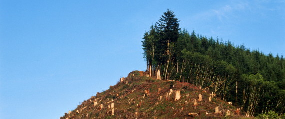 |
| Rex Ziak via Getty images, via Huffington Post "Deforestation: The Over-looked Climate Driver and What You Can Do About it." |
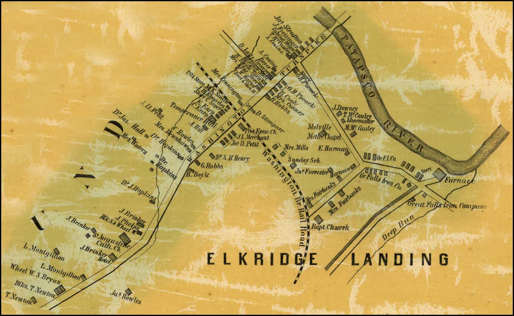 |
| Detail of Elkridge Landing from Simon J. Martenet, map of Howard County, 1860 |
The discharge and erosion progressively obstructed smaller waterways
with silt and sedimentation, causing smaller creeks to dry up completely and
larger streams and rivers to change course or slow in productive volume.
Silting
had become so severe in Maryland by 1753 that the Patapsco River was in
jeopardy of silting over and navigation to Elkridge Landing was extremely
difficult.
In an attempt to remedy this, Maryland General Assembly passed “An Act to prevent injuring the Navigation
to Baltimore-Town, and to the Inspecting House at Elk-Ridge Landing, on
Patapsco River,” stating that:
[due] to “opening and digging into the Banks of Patapsco River, for Iron
Stone, large Quantities of Earth and Sand are thrown and washed into the said
River, and navigable Branches thereof, by which Practice (if continued), the Channel
of the said River, and navigable Branches aforesaid, will, in a short Time, be
so filled up, that Vessels of any Burthen must be prevented from coming into
the best and most secure Harbours in the said River, and the Navigation thereof
greatly obstructed.” (MD
General Assembly, 1752-1754)
This act, limiting the
placement of earth, sand, or dirt,
below the high water on Patapsco appears to be a “lesson learned” from the
previous Acts of 1719
and 1736,
encouraging the production of iron milling within the providence.
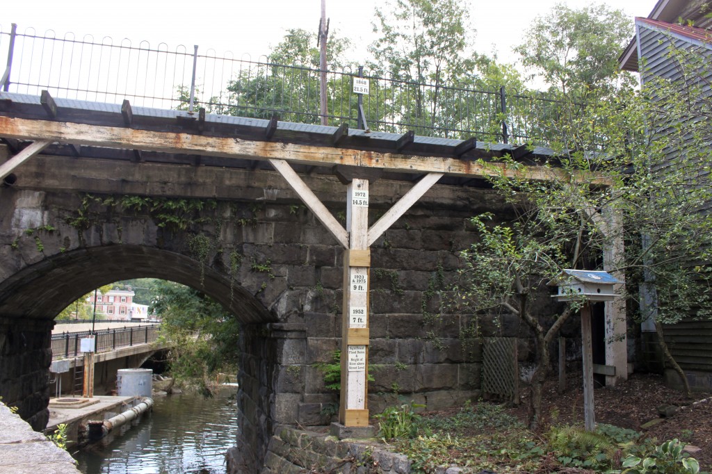 |
| Ellicott City Flood gauge and Historical Dates, Maryland Historic District.com, 2011 |
However,
even with this act, the damage had already begun. Even as late at 1910-1911 the
river silt and deforestation of the hilly terrain were of major concern. As described in the Maryland State Department of Forestry’s report for that year, the “steep
slopes have been cleared and are now washing badly” causing silting in the
river channel, and the river is no longer navigable to Elkridge Landing. (Maryland Board of Forestry, 27) While
of primary focus, river navigation is not the only concern brought on by
silting. Due to the increase sediment in the river and streams, the waterways
were unable to carry the same volume of water as before without overflowing their
banks. Soon, due to these environmental changes colonist faced a new problem:
Flooding.
Sources:
Archives of Maryland. Proceedings
and Acts of the General Assembly, 1752-1754. reproduced in William Hand Browne, Edward C. Papenfuse, et.
al. eds., Archives of Maryland, 215+ volumes, (Baltimore and Annapolis, Md.,
1883-), Volume 50, Page 374-375. http://msa.maryland.gov/megafile/msa/speccol/sc2900/sc2908/000001/000039/html/am39--486.html
Martenet, Simon J.. “Detail of Elkridge Landing” Map of Howard County, 1860. Library of Congress reproduced in The State of Maryland Presents: Beneath the underground: The flight to Freedom and Communities in Antebellum Maryland – An Archives of Maryland Electronic Publication. (Baltimore and Annapolis, Md., 1883-), MSA SC 1213-1-467. http://slavery.msa.maryland.gov/html/mapped_images/elkridgelanding.html
Maryland Board of Forestry. “Report of the State Board of Forestry for 1906 and 1907.” Baltimore, MD: State of Maryland, 1907.
Purvis, Thomas L.. Almanacs of American Life: Colonial America to1763. Edited by Richard Balkin. New York: Facts On File, Inc., 1999.
Sharp, Henry K. “”on the great fall of Patapsco River” A Case Study of Industry and Urbanism in Late-Colonial and Early-Republican Maryland.” PhD diss., University of Virgina, May 2010, 53.
Audra Campbell
December 17, 2015
Vietnam War
Commemoration Blog Entry 1
At The United States
of America Department of Defense Vietnam War Commemoration I have been
privileged to help in several areas of their mission. There are numerous goals
of the Commemoration, but the primary goal is to thank and honor Vietnam War
Veterans for their service, sacrifice, and valor for the United States of
America. With the history of how the Vietnam Veterans were treated poorly upon
their return to the USA and how there was not enough support for them during
and after the war both by the US government and the Civilian population, the
government has sanctioned the Commemoration in an effort to try to right this
wrong and ensure that these veterans and their families are shown the respect
and honor that they deserve. The idea that veterans are never to be treated like
that again is strong at the Commemoration, and the effort to make sure that
these events are never repeated for other veterans is a primary motivation. This
is a really great project for me since my Dad was enlisted during the Vietnam War.
Although he did not serve in combat, the Commemoration still honors him as well
as all service men and women for their service. The project that I am involved
in during this internship is helping them with gathering partners for the
Commemoration. Partners must be organizations that have at least two events a
year that honor veterans. It is free to become a partner and is open to
military and civilian organizations. My primary function in the Commemoration
has been to help them vet (review) these applications. This involves me
researching to verify that the organization applying to be a partner is indeed
a real organization and then helping them through the application process by
making follow up calls and emails. These partners are supplied with flags,
fliers, posters, bumper stickers, certificates, pins, etc. so that they can
better honor veterans. I also help make the partner starter kits, the
information folders, and assemble the certificate and lapel pins packets. The
incredible care and detail that each member of the team puts into every aspect
of what they do so that everything is perfect for the veterans is inspiring to
be around. A powerful and eloquent statement to summarize their goals and motto
for veterans is, “A grateful Nation thanks you.” It is important to the
Commemoration that these deeds and these veterans never be forgotten for their
acts of sacrifice and valor.
Wednesday, December 16, 2015
First Industries -- First Families
Near the juncture of Rockburn
Branch and the Patapsco River lies the charming, historical estate of Belmont.
A location with ties to both Howard Counties early history as well as one of Maryland's first industries -- iron making. The property is known as the home of the Dorsey family for seven
generations, but was originally patented Dr. Mordecai Moore in 1695 under the
name “Moore’s Morning Choice.”(Schraff, 38) It was not until nearly 1732 that
Caleb Dorsey Sr. purchased the land and combined it with neighboring tract, "Dorsey's Chance,” before gifting them
to his son, Caleb Dorsey Jr under the new name “Moore's Morning Choice
Enlarged.”(Sharp, 53)
 |
| Belmont Manor - RS |
The 1766-acre parcel was ideal for
the industriously minded Caleb Dorsey Jr. Just inside the southern limits of the property,
“a sizable stream (Rockburn Branch) traversed the ridge and descended towards
the Patapsco.” (Sharp, 53) The stream and the river with their red-orange clay deposits
provided the perfect location Caleb Jr’s iron ambitions.
Dorsey was not alone
in this thinking. As early as 1719, the Maryland General Assembly approved “An Act for the Encouragement of an Iron Manufacture, within
this Province,” promoting
the production of iron in the region. The General Assembly believed:
“that there are very great Conveniences of carrying on Iron-Works
within this Province, which have not hitherto been embraced
for want of proper Encouragements to some first Undertakers, altho the
Consequences thereof might not only be considerably advantageous to the
Persons immediately concerned therewith, but also to the Public
Trade of Great-Britain, and this Province”(MD General Assembly, 1717-April, 1720)
Then again,
in 1736, the General Assembly thought the work of iron making so important to
the state that they passed an additional edict, “An
Explanatory Act of the Act Entituled An Act to encourage Adventurers in Iron
Works.” This act, excused workers
at Iron works from road building and maintenance. (MD General Assembly, 1733-1736)
 |
| Excerpt from 1974, Dennis Griffith map, "Map of the State of Maryland laid down from an actual survey..." |
Taking advantage
of these acts, Dorsey applied for a condemnation
writ from the Chancery Court in 1755. After receiving the writ, awarding him a
100-acre parcel for an iron furnace surveyed out of “Moore's Morning Choice
Enlarged,” Caleb Jr, along with his brother Edward and an iron master Alexander
Lawson formed the Elk Ridge Company Furnace. (Singewald, 168) Three years later, the company expanded, applied
for an addition write location near Long Bridge Branch and the head of Curtis
Creek (Curtis Creek Furnace). (Singewald, 168) Then, in 1761, Caleb Dorsey Jr. acquired a third forge, on his
own, across the Patapsco River from the original Elk Ridge Furnace location.
This final site would later be purchase by the Elliott brothers and renamed
Avalon Iron Works. (Singewald, 173)

The Dorsey’s and Lawson did well in the iron industry until their deaths. Both Edward Dorsey and Alexander Lawson passed
away in 1760 and Caleb Jr. in 1772. After their deaths, the properties Caleb’s
minor son, Edward inherited the properties and some were auction off to cover a
portion of the Dorey’s debts at death. Once reaching adulthood, Edward spent
the remainder of his life attempting to gather and repair the pieces of the
auction off Elk Ridge Company Furnace. After numerous attempts, the estate was
not officially settled until a final Chancery Court decree 1815; 16 years
follow Edward’s death. (Sharp, 57)
Sources:
Archives of Maryland, Proceedings
and Acts of the General Assembly, 1717-April, 1720 reproduced in William Hand Browne, Edward C. Papenfuse, et.
al. eds., Archives of Maryland, 215+ volumes, (Baltimore and Annapolis, Md.,
1883-), Vol 33, Page 467 (hereinafter cited as Archives of Maryland). This
series is ongoing and available on line at http://aomol.msa.maryland.gov/ where volumes, collectively or individually,
can be searched electronically. http://msa.maryland.gov/megafile/msa/speccol/sc2900/sc2908/000001/000033/html/am33--467.html
Griffith, Dennis, James Thackara and Vallance, John. “Map of the State of Maryland laid down from an actual survey of all the principal waters, public roads, and divisions of the counties therein; describing the situation of the cities, towns, villages, houses of worship and other public buildings, furnaces, forges, mills, and other remarkable places; and of the Federal Territory; as also a sketch of the State of Delaware shewing the probable connexion of the Chesapeake and Delaware Bays.” (Philadelphia, J. Vallance) 1795. http://www.loc.gov/item/76693265/
Scarff, John H. "Belmont." Maryland Historical Magazine 48 (March 1953) 1: 37-52. Available online from the Maryland state archives http://msa.maryland.gov/megafile/msa/speccol/sc5800/sc5881/000001/000000/000189/pdf/msa_sc_5881_1_189.pdf .
Sharp, Henry K. “”on
the great fall of Patapsco River” A Case Study of Industry and Urbanism in
Late-Colonial and Early-Republican Maryland.” PhD diss., University of Virgina,
May 2010, 53.
Singewald, Jr.,
Joseph T. “The Iron Ores of Maryland, With an Account of the Iron History.”
Ph.D. Diss. Johns Hopkins University, 1911. https://archive.org/stream/ironoresmarylan00singgoog/ironoresmarylan00singgoog_djvu.txt
Montgomery History – Beall-Dawson House Museum and Dr. Stonestreet Museum of Nineteenth Century Medicine

The front door of the Beall-Dawson House
For the third portion of my internship this past summer with
Montgomery History, I worked as a docent in the Beall-Dawson and Dr.
Stonestreet museums. The museums are open Wednesday through Sunday, 12:00 to
4:00. Wednesday through Friday they use volunteers and on the weekends they
have two paid Weekend Coordinators that alternate every other weekend.
The tour consists of the Dr. Stonestreet Museum of
Nineteenth Century Medicine, which takes place in the small building that was
his office. Inside the building are his actual examination table and a number
of instruments and tools doctors of the time would have used. Some were Dr.
Stonestreet’s, though most come from other doctors that practiced at the time.
Every second Sunday of the month Clarence Hickey from the Speakers Bureau comes
to volunteer and act as the Dr. Stonestreet interpreter. He has also written a
book about the man, one that is sold in the gift shop.

Dr. Stonestreet’s office

The 1940s addition where the gift shop is located
The gift shop is located in one half of the frame construction
addition built in the 1940s when the Davis family moved in. Part of my job as
docent is helping out with the gift shop and keeping track of anything a
visitor shows an interest in. If they mention a book or item that they’re
interested in but we don’t have, I let the shop manager know.

Subscribe to:
Posts (Atom)